Posts

San Bruno - San Andreas Lake Trail

Image
Spring is coming.. spring is coming.. I want to just spend the entire day outdoors and enjoy the beauty all around - flowers blooming, birds singing and everything welcoming the sunshine... We decided to go to the San Andreas lake trail in Millbrae.  The idea of a lake and natural beauty has its own draw.  The trail is listed as an easy trail on All Trails and out and about 7 miles.  You could argue there isn't a big area marked as a parking lot or a trail beginning. As you cross Skyline Blvd. you see a tiny parking area with parking for about 10 cars. We found parking and start walking. It's hard to say where the trial begins as it goes both ways. We checked the maps and started walking towards the lake. As we started walking we realized it is a connected trail and it all forms part of the San Francisco Peninsula Watershed.  Trail Map The trail runs parallel to the freeway on one side and has a picturesque view of the mountains on the other side. You can see and hea...

HMB: Purisima Creek Redwoods Open Space Preserve: Purisima Creek Trail

Image
How about spending the day outdoors after a stressful week? Get all the fresh air combined with exercise and catching up all at the same time... Cannot beat that!!! After last week's strenuous hike at the Nisene forest, we decided to take it easy and pick a closer, easier hike. We went to the Purisima Creek trail near Half Moon Bay (HMB).  Trail Map It was a lovely Saturday with the sun shining bright after it rained Friday night. The morning was nippy but too good to miss out. We started later than usual - I guess we are all ready for spring and the longer days it brings ☺.  We started around 11 and it took us an hour to get there. The drive took longer as we hit beach-going traffic. After you are past the HMB beaches you come across ocean views on one side and mustard fields on the other. We had to take a left on Verde Rd to reach our destination. After the left, you feel like you have left the beach town behind and are entering farmland. After about 3 miles inland we reache...

Aptos - The Forest of Nisene State Park

Image
National Geographic says one major travel trend that has emerged in this pandemic is people's appetite for the outdoors. I couldn't agree more. I personally have started paying so much attention to all things outdoors since last year. Last year we hiked about 65 miles and this year my goal is to double it and blog about every single one of them. Have you ever wondered how is life in a forest? When we were driving to get there my mind kept racing trying to find an answer. The drive was beautiful as we passed through Capitola and the town of Aptos with a quaint downtown. Cell phone signal gets choppy as you leave downtown as you are very close to the forest. The last call I received was from A at quarter past 10 that they were at the park entrance and there were a few more parking spots left. We were about 10 minutes away so assumed we will make it. By the time we reached, the park ranger had already started turning cars around since parking was full.  Park Map We drove a mile an...

Morgan Hill - Uvas Canyon - Knibb Knob and Waterfall Loop Trail

Image
How did you spend your Valentine's Day? Keep reading to know about the amazing day I had with my near and dear ones in a picturesque canyon.  Trail Map With the recent rains, the canyons were the perfect place to go with brimming waterfalls and lush greenery. The 60s weather made it a great hiking day. Too good..right? There is a small gotcha though - you cannot make an impromptu plan and go there as you have to reserve parking ahead of time. With COVID restrictions this is a good idea but requires planning. We reserved our spot about a week before the hike.  The drive to the canyon gets picturesque with farms as far as the eye can see once you exit the freeway.  Once we got there the ranger greeted us warmly, checked us in, and gave us maps plus tips. There are 3 parking lots split into day use and overnight camping lots. As soon as we got out of the car - we saw a huge open area spread out with benches, an amphitheater setup, and restrooms. The kids immediately started ...

South San Jose - Los Alamitos Creek Trail

Image
What do you do when you are cooped up indoors due to bad weather, rainfall with a possibility of an atmospheric river? You start dreaming and planning.... Sunshine, Fresh air, Great Outdoors... Hmmm Sounds wonderful. It was also Ms birthday in the past week so even more reason to get out and meet and celebrate.  We quickly decided to goto the South San Jose - Los Alamitos Creek Trail near the  Almaden Expressway . This paved trail is located in a semi-rural setting with embedded parks and entrance points all along.  The parking lot is small with a max capacity of around 15-20 cars but there is ample parking along the many cross-streets.  Trail Map As soon as we parked we saw a bridge nestled around the creek with trees. There were a lot of people biking and walking through the trail. Imagine crossing a bridge into this wonderland with beautiful sounds of the creek flowing downstream. We started around noon and took the fitness route. The fitness route has s...

Berkeley - Tilden Regional Park - Inspiration Point

Image
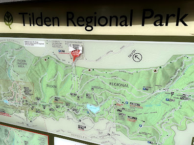
We hadn't been to the Tilden Regional Park despite being in the Bay Area for several years.  This park has many scenic hikes and of course, being in Berkeley you have the added bonus of amazing views of the Bay, Downtown San Francisco, and the Golden Gate Bridge. Something about hikes with views...Who can say no to that?   Park Map I would describe this as a perfect Saturday hike. It was a clear January morning with the sun shining bright and temperatures in the 70s. It would be an injustice to not get some tan on such a gorgeous day. One of the perks of being in the Bay Area ☺ We started at the Inspiration Point trailhead. The trailhead parking lot is small but there is ample street parking. We found many hikers and bikers enjoying the gorgeous weather that day. It definitely warmed my heart thinking we picked a good spot but also a bit scary. We ensured that everyone had their masks on and had hand sanitizers on them. With all checks done we were ready to start a f...

Palo Alto - Foothills Park - Los Trancos Trail

Image
New Year...New Beginnings...New Adventures. Aren't we all ready to forget all about 2020 and start 2021 anew? I hope the new year brings health and happiness to everyone.  We decided to start the New Year with a positive outlook and the desire to do everything right - eat right, exercise, mindfulness. What better way than to hike to the mountains and enjoy some beautiful weather. We had heard of a new Palo Alto Foothills park being  recently  opened to the general public. This park was only open to Palo Alto residents for the last 50 years but thanks to activists it was now available for everyone to enjoy.  The weather was a bit chilly on 1/1 and rains were expected to start on 1/2 so the inner voice was strong to say let's go and enjoy the day...  Park Map We planned to start the hike around 10 am to get the most benefit of the day. Maps show you two locations - Palo Alto and Los Altos when you enter the address. We picked the Palo Alto location as a few of us ...